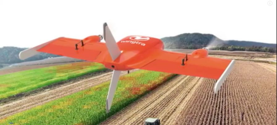
Following the launch in April, the WingtraOne is now spreading its wings in international in the United States and China. WingtraOne a professional drone that simplifies mapping and surveying by combining the benefits of agile multirotors and high endurance fixed-wing aircrafts.
Wingtra, a spin-off from the Autonomous Systems Lab at ETH Zurich has today announced partnerships with resellers in China and the US. The new partnership allows Wingtra to affirm their existence in the two markets by introducing their recently launched drone, WingraOne, a flying robot that takes off and lands like helicopters, but flies like planes.
WingtraOne is swiftly emerging as the favourite choice of professional users for aerial data collection worldwide. “We are proud to say that our users come from areas as diverse as surveying, precision farming, glacier monitoring and wildlife monitoring,” says Basil Weibel, CEO Wingtra.
Bridging the gap betwen two worlds
With the drone technology emerging rapidly, users have been turning to the Unmanned Aerial Vehicle market for aerial data collection due to the combination of high range and usability. However, the choice has typically been between fixed-wing airplanes and multirotors. Fixed-wing airplanes offer long range but can be too cumbersome to use. Either they need long runways, limiting the options for take-off, or need catapults. In contrast, multirotors offer great flexibility for take-off and landing, and in turn, ease of use. However, they are severely limited in flight time and speed – the most popular quadcopters, for example, can only offer a flight time of around 20 minutes covering roughly 40 hectares.
As such, Wingra developed a hybrid drone “WingtaOne” combining the best of both worlds by briding the gap between usability and high range.WingtraOne is designed as a tailsitter drone that takes off and lands vertically (VTOL) like a multirotor, but flies like a fixed-wing airplane in air. This efficiency in flight gives it a flight time of up to 55 minutes covering anywhere between 280 and 400 hectares at 3cm/px GSD depending on the specific sensor – the same area as 570 football fields.
This ease of use is greatly amplified by its flight planning software, WingtraPilot. The process of planning a survey takes roughly 5 minutes. Then, with the press of a button, the WingtraOne takes off, collects aerial imagery, and lands — all fully autonomously. The user, thus, does not have to worry about needing any pilot training.
With its high payload capacities, the WingtraOne offers a variety of high-end sensors to generate high-resolution imagery for orthophotos, 3D reconstructions, cloud points and NDVI maps. Wingtra’s selection includes the 42-megapixel full-frame Sony RX1RII. Thanks to the vertical landing, the cameras are well-protected and are never at a risk of damage by belly landings.
(RAN)


Please login or sign up to comment.
Commenting guidelines